GPS
Locator Guys’ GPS and mapping solutions help crews move from paint marks to usable digital utility records. Current options combine rugged GNSS receivers, field tablets, and integrated locate-and-map tools to support utility mapping, GIS workflows, and stronger asset documentation for contractors, municipalities, and utility teams working in demanding environments.
Why Buy GPS Equipment from Locator Guys?
Selecting GPS equipment involves more than comparing specifications. Locator Guys works closely with customers to identify the right solution for their mapping, utility locating, and field data collection needs, backed by knowledgeable service and responsive support.

Utility GPS Mapping System Price & Comparison Guide
Utility GPS mapping systems are specialized tools that combine high-accuracy GPS/GNSS receivers with utility locating equipment or data collectors to precisely map underground utilities. In this guide, we’ll explain what utility GPS systems do, compare GPS vs. traditional locating, outline price ranges vs. accuracy levels, and provide a brand comparison of GPS mapping equipment. We’ll also cover who needs GPS mapping, how these systems integrate with locators & GPR, and answer common FAQ. This price and comparison guide is written for contractors, engineers, utility professionals, and municipal buyers looking for technical accuracy and clear insight into utility GPS system price and performance.
What Utility GPS Systems Do
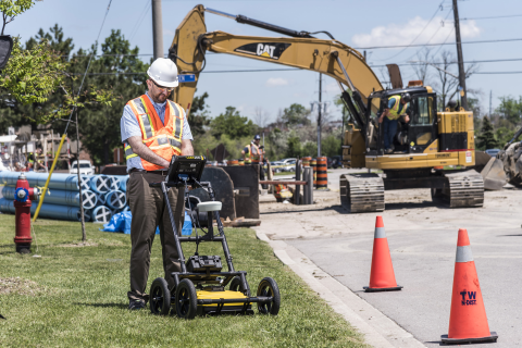
Utility GPS mapping systems enable professionals to locate underground pipes and cables and simultaneously record their precise geographic coordinates. In practice, this typically means pairing a utility locator or ground penetrating radar (GPR) with a GPS/GNSS receiver so that each locate (or GPR target) is tagged with latitude/longitude (or GIS coordinates). The result is a digital map of buried assets that can be imported into GIS software or CAD plans for as-built documentation and future reference. In other words, instead of manually sketching utility locations on paper plans or relying on painted marks alone, a utility GPS mapping system automates the mapping process with geospatial accuracy.
Modern utility locators like the Radiodetection RD8200 series integrate GPS directly into the receiver, so technicians map while they locate. For example, the RD8200G locator includes an internal GPS to add positional data to each survey measurement, without needing any extra device. This allows the operator to capture location coordinates for each utility line located, simplifying integration with GIS databases. High-end models even incorporate RTK (Real-Time Kinematic) GNSS for survey-grade accuracy, meaning utility positions can be recorded within an inch or centimeter. By contrast, traditional locating involves finding the utility with an electromagnetic locator or GPR, then marking it and later manually measuring or inputting its location, a process prone to human error and extra labor. Utility GPS mapping systems eliminate those extra steps by providing precise, real-time digital mapping in the field.
Many utility GPS systems also support wireless data transfer and GIS compatibility. Devices often connect via Bluetooth to mobile apps or controllers, enabling real-time map creation. For instance, Radiodetection’s GPS-enabled locators can interface with GIS mapping apps like PointMan or Subsurface Maps to build maps on-site. Data (e.g., utility line coordinates, depth readings) can then be exported in formats like CSV, KML, or shapefiles for integration into ArcGIS or other asset management systems. This digital workflow provides a far more efficient and accurate record of underground utilities compared to traditional methods.
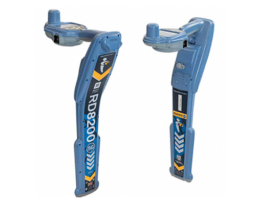
RD8200SG: Survey-Grade Locating with RTK Precision
Survey-grade accuracy meets rugged design — the RD8200SG delivers real-time RTK precision and effortless utility mapping.
Juniper Systems: Rugged Devices for Precise Location Data
Track assets, survey structures, or collect field data with Juniper Systems’ rugged devices. As the premier dealer, C&S Solutions offers reliable, durable solutions for precise location data in surveying, mapping, and utilities.
Our Juniper Systems Products:
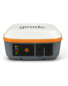
Geode GNS3S + GNS3M
Mesa 3 Base Tablet
CT8X Rugged Tablet
Why Choose Juniper Systems?
Juniper Systems offers rugged, reliable devices for industries like surveying, agriculture, and utilities. Paired with Locator Guys’ expert support and free on-site training, you get the best tools and service for your field operations.
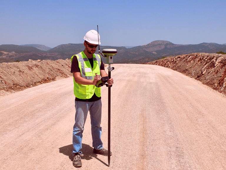
Price Ranges & Accuracy Levels
How much does GPS mapping equipment cost? The price of utility GPS mapping systems varies widely based on the accuracy level and whether the system is a standalone GNSS unit or an integrated locator+GPS. Below is a breakdown of typical GPS mapping equipment cost ranges versus the accuracy you can expect:
| Service | Details |
|---|---|
| Accuracy Level | ~3–5 m |
| System Type | Smartphone / Basic Handheld |
| Reliability | Inadequate for utility precision |
| Approx. Price | <$1,000 (Not recommended for utilities) |
| Service | Details |
|---|---|
| Accuracy Level | ~0.3–1 m |
| System Type | Handheld GNSS Receiver |
| Example | Juniper Geode GNS3S (SBAS) |
| Approx. Price | $2,000 – $3,000 |
| Service | Details |
|---|---|
| Accuracy Level | ~30 cm |
| System Type | High-End GNSS / Locator |
| Examples | Geode GNS3M, RD8200G |
| Approx. Price | $3,000 – $6,000 |
| Service | Details |
|---|---|
| Accuracy Level | ~1–2 cm (RTK) |
| System Type | RTK-Capable GNSS System |
| Example | Radiodetection RD8200SG |
| Approx. Price | $6,000 – $10,000+ |
Accuracy vs. cost
In general, the higher the accuracy, the higher the price. Mapping-grade GPS (sub-meter) receivers provide sufficient accuracy for general GIS asset mapping at a few thousand dollars. These often rely on free SBAS corrections (e.g., WAAS) for ~60 cm accuracy. Stepping up to decimeter or sub-foot accuracy usually requires multi-frequency GNSS hardware and possibly paid subscription services (like Atlas L-Band or differential corrections). The Juniper Geode GNS3, for example, is upgradeable from sub-meter to decimeter or centimeter accuracy depending on the subscription or RTK network you use. Its price (~$2.5K–$2.9K) is relatively low because you still need to account for external correction service costs to reach the highest precision.
For true survey-grade (centimeter-level) mapping of utilities, expect to invest at the upper end. This can be achieved by pairing a high-precision GNSS rover with your locator or by using an integrated solution like the RD8200SG. The RD8200SG comes with an RTK-enabled GNSS and is priced around $9,000 with accessories, reflecting the added hardware and technology for centimeter accuracy. In comparison, the non-GPS version RD8200 (for locating only) costs about $5,1680, so adding mapping capability and higher accuracy roughly doubles the investment. Utility GPS system price points are thus closely tied to accuracy: a system that simply logs points for mapping (within a meter) can be mid-range, while one that provides survey-quality coordinates in real-time will be a premium solution.
Geode GNS3S + GNS3M
SCALABLE REAL-TIME GNSS RECEIVER
Looking for a simple and scalable sub-meter, sub-foot, and decimeter GNSS solution at an affordable price? With the Geode, you can easily collect real-time GNSS data without the huge price tag or complexity of other precision receivers.
Designed with versatility in mind, the Geode works well with most Apple®, Windows®, and Android™ devices. An integrated antenna makes messy cables a thing of the past, yet still has an external antenna port if it's needed. Take the Geode with you mounted on a pole, in a pack, or held in your hand to collect real-time precision GNSS data wherever the job takes you.
Features:
- Scalable Accuracy
The Geode GNS3 provides sub-meter, sub-foot, and decimeter accuracy options. - Open Interface (BYOD)
Use Geode with any of Juniper Systems' handhelds or with your own iPhone™, iPad™, Windows®, or Android™ device. - All-day Battery Life
The Overtime Technology battery provides enough power for long workdays, while conserving power in extreme temperatures. - Simple to Use
It's "one button simple" design provides intuitive and easy operation. - Compact Size
Small and lightweight, the Geode is easy to pack around all day. - All-In-One Design
The inside of the Geode contains the receiver, antenna, and battery, making it easy to carry around and mount without a mess of wires. - Affordable Price Points
Professional accuracy at a price you can afford. - Juniper Rugged™
Designed to withstand harsh environments for consistently reliable performance.
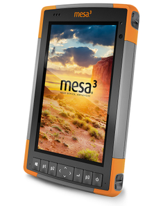
Mesa 3 Base Tablet
Your Office, Anywhere
With best-in-class features including an ultra-rugged ergonomic design, sunlight-readable display, and all-day battery life, Mesa® Rugged Tablets provide the ultimate device for a variety of mobile data collection applications.
Features:
- Waterproof, dustproof, shockproof
- Extreme temperature endurance
- Ergonomic design for minimal user fatigue
- All-day battery life
- Large 7'' sunlight-readable display
- Racing-fast processor options
- Designed and assembled in the United States
- Live and individualized customer support
- Customizable
- Optional Class 1, Div 2 certification for hazardous locations
Running Windows 10 or Android 11 operating systems, Mesa Rugged Tablets carry out the entire data collection process with ease from start to finish. Snap a photo, record field notes, capture a GNSS location, and analyze data – all in the palm of your hand. Its racing-fast processor and ergonomic design ensure maximum efficiency and minimal fatigue. With all the functionality of a desktop computer packed into one ultra-tough tablet, the Mesa will truly become your office, anywhere.
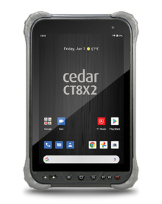
CT8X Rugged Tablet
Work Hard, Worry Less
Juniper Systems' Cedar line of rugged Android tablets and smartphones offer users an upgrade in durability and performance when a consumer tablet just won't cut it. Designed for all-day use in any environment, the CT8X2 offers impressive processing power running on an Android™ 10 operating system.
Features:
- Processing Power: The most powerful Cedar tablet to date, equipped with a lightning-fast processor for impressive speed, display performance, and image quality.
- Versatility of Android: Running Android 10 with Google Mobile Services (GMS), giving access to the full Google Play Store.
- GNSS Capabilities: Uses a u-blox M8 GNSS chip for up to 1-meter GPS accuracy in open sky, and 5 meters under tree canopy. Can pair with the Geode Sub-meter GPS Receiver for higher accuracy.
- Battery Life: Swappable lithium-ion battery provides 8 hours of continuous use. Swap for an additional 8 hours without downtime.
- Sleek and Rugged Design: Rated IP67, operates from -4°F to 140°F, with a Gorilla Glass screen that withstands multiple 1-meter drops.
- Affordability: Budget-friendly with quantity discounts for equipping teams.
- Optional Reader Attachments: Attach 1D/2D barcode or RFID readers easily via back-facing pins.
GPS vs. Traditional Locating
Integrating GPS mapping with utility locating is a game-changer in the field. Here’s a quick GIS GPS comparison between modern GPS-enabled locating and traditional methods:
Traditional Locating:
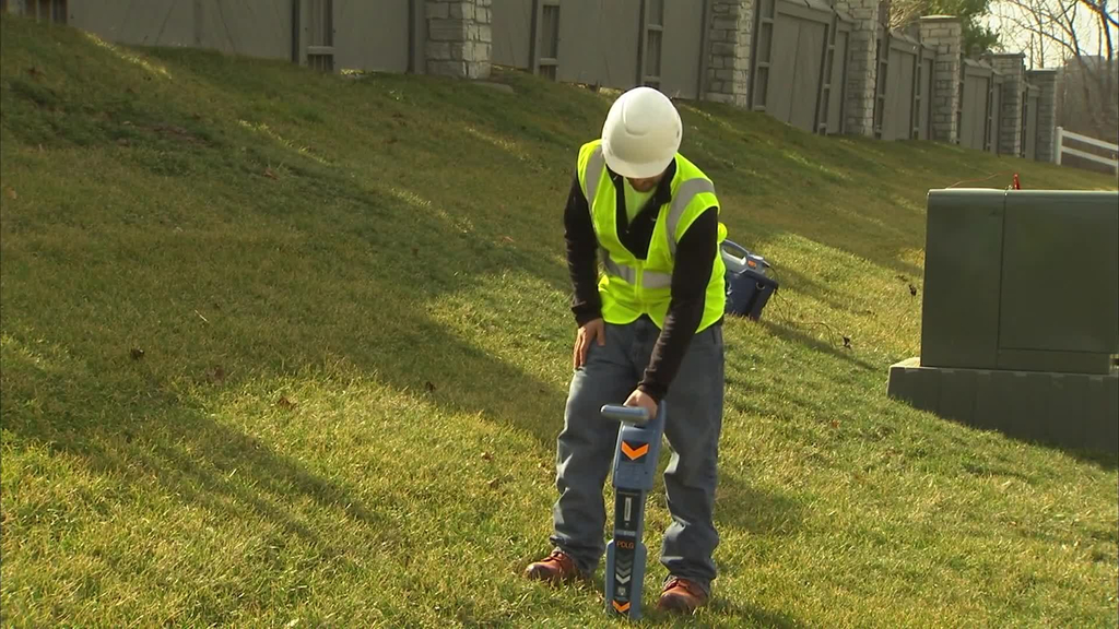
A technician uses an electromagnetic locator or GPR to find buried utilities and marks their positions with flags or paint. Mapping the utilities into GIS is a separate, manual step, often using measuring tapes, sketches, or after-the-fact GPS waypoint collection. This two-step process can introduce human error and missing data, since the location logging is done later and by hand. In busy environments, it’s easy to lose track of which mark corresponds to which utility on a map. In short, traditional locating finds the utilities but does not automatically produce digital maps.
GPS-Integrated Locating:
A utility GPS mapping system merges these steps. As the technician locates a pipe or cable, the system automatically records the GPS coordinates of that location. For example, Radiodetection’s GPS locators use internal GPS and Bluetooth to log each locate point into a mapping app in real time. This synchronized data capture means the map is created on the go, with no need for separate surveying later. The benefits are significant: higher accuracy (especially with RTK models), immediate digital records, and proof of work. In fact, GPS models add the benefit of proving survey locations, providing documented evidence of exactly where a utility was found.
Efficiency and Accuracy:
With GPS mapping, field workflows are streamlined. Crews can cover an area once, locating and mapping simultaneously, which speeds up the job and reduces return visits. Real-time mapping also reduces errors. Coordinates are captured under the same conditions as the locate (no guessing later). Traditional locating might suffice for simple jobs where approximate positions are okay, but when precision and documentation are required, GPS-enabled systems provide unmatched accuracy and confidence. They effectively eliminate the uncertainty of manual mapping by delivering precise, repeatable data for each buried asset found.
In summary, traditional locating is all about detection, while GPS-integrated locating is about detection + documentation. For modern infrastructure projects, the latter has become the gold standard in damage prevention and utility asset management.
Brand Comparison (Utility GPS Units)
When comparing utility GPS mapping equipment, it’s important to look at the types of systems offered by different brands. Locator Guys focuses on GPS units from top manufacturers that they carry, notably Radiodetection and Juniper Systems. Each takes a different approach to utility mapping:

Radiodetection (RD8200G & RD8200SG):
Radiodetection’s approach is to integrate GPS directly into the utility locator. The RD8200G is a precision line locator with built-in GPS logging, allowing you to map lines as you locate them. It’s designed for utility crews who want one device to do both jobs. The RD8200G captures location data (with roughly sub-meter accuracy) for each locate and can upload it to mapping software via Bluetooth. Stepping up, Radiodetection’s RD8200SG is a survey-grade locator with RTK GNSS built in. This model achieves centimeter-level accuracy by using real-time kinematic corrections, effectively turning the locator into a survey instrument. Radiodetection GPS locators are rugged, field-proven tools aimed at professionals who need unmatched accuracy in a single device. They tend to be higher in price (as noted, ~$5.8K for RD8200G, ~$9K for RD8200SG) but deliver seamless locate-and-map capability in one workflow.

Juniper Systems (Geode GNSS Receivers):
Juniper Systems offers standalone GNSS receivers and rugged data collectors rather than combined locators. The Juniper Geode GNS3 series is a popular choice for utility mapping when you want a flexible GNSS unit that can pair with various devices. The Geode is a small, rugged receiver that provides scalable accuracy from sub-meter to centimeter, depending on the model and subscriptions. For example, the Geode GNS3S is a sub-meter receiver (~$2,495), and the GNS3M (~$2,895) is multi-frequency and upgradeable to RTK for cm-level work. Juniper’s solution typically requires a separate mobile device or tablet (such as their Mesa 3 Rugged Tablet) to run a mapping app and interface with locators via Bluetooth. The advantage of this approach is versatility. You can use the GNSS receiver for utility mapping, surveying points, environmental data collection, etc., by attaching it to a pole or even a GPR cart. It’s a Bring Your Own Device (BYOD) style system. Juniper’s gear is known for being ultra-rugged and easy to use, with all-day battery life and cross-platform compatibility (Android, iOS, Windows). In short, Juniper provides the GPS piece of the puzzle with professional accuracy at a lower entry cost, but you’ll integrate it with other equipment for a complete locating & mapping solution.
Which to choose?
If you want an all-in-one solution and your primary task is locating utilities, Radiodetection’s GPS locator systems offer turnkey operation. You pull the trigger and get location data without hassle. They are ideal for utility companies and locators who map as they locate, and need robust depth finding plus mapping in one device. On the other hand, if you already have locating tools (EM locators, GPR, etc.) and want to add high-accuracy mapping to your toolkit, a Juniper Geode GNSS paired with your existing gear (and perhaps a tablet) can be a cost-effective, flexible choice. It’s also favored by surveyors or engineers who might use the same GNSS for multiple applications. Both brands emphasize ruggedness and support. For instance, Juniper devices are Juniper Rugged™ and built for harsh environments, and Radiodetection locators are known for durability and backed by training and support from
Who Needs GPS Mapping?
Who benefits the most from utility GPS mapping systems? In today’s infrastructure and construction landscape, a wide range of professionals and organizations find value in these systems:
Utility Companies & Municipal Agencies: Public utilities (water, gas, electric) and city public works departments are often required to maintain accurate maps of underground assets. Regulations and internal policies demand that new installations be mapped precisely to prevent future utility strikes and to plan maintenance. GPS mapping systems allow city engineers and utility GIS teams to digitally record assets as they are located or installed, ensuring compliance and up-to-date records. Municipal and state agencies (e.g., DOTs) also use these systems for asset management and project planning, especially when coordinating road works or utility relocation.
Contractors & Construction Firms: Excavation and drilling contractors, as well as engineering firms, use GPS utility mapping to avoid costly hits and to document existing utilities before breaking ground. For example, a subsurface utility engineering (SUE) contractor might locate all utilities on a site with electromagnetic locators and GPR, then use a GPS mapping unit to capture each line’s position for the client’s CAD drawings. The precision offered (sub-foot or cm) can be crucial when plotting existing lines relative to new construction plans. By adopting GPS mapping, contractors can prevent damage, reduce downtime, and provide deliverables (digital maps) to clients, demonstrating all due diligence was done.
Surveyors & Engineers: Land surveyors and civil engineers often work alongside utility locators for projects. With high-accuracy GNSS receivers (or survey-grade locator systems), they can integrate utility location data into their survey coordinates. This is especially useful for design surveys or when updating GIS utility layers. Rather than approximate a utility’s path from paint marks, they can gather georeferenced points directly. Survey-grade utility mapping is now an expectation on many large projects (e.g., new highway, pipeline, or facility construction).
Facility Managers & Campus Maintenance: Universities, industrial campuses, hospitals, and large facilities have their own underground networks. GPS mapping helps these entities build their own GIS of buried plumbing, electrical lines, fiber optics, etc. Over time, having an accurate map reduces the risk of outages and helps in planning upgrades or repairs. Even smaller utility providers (co-ops, private developments) who maintain maps can benefit from periodically remapping with GPS to verify records.
In essence, anyone responsible for underground infrastructure can use GPS mapping. From contractors to utility professionals to municipal buyers, the investment in a utility GPS mapping system pays off by improving safety, efficiency, and confidence in knowing exactly where things are buried. These solutions are built for contractors, utility companies, and municipal agencies to ensure accurate mapping and streamlined workflows across teams.
Integration with Locators & GPR
Utility GPS mapping systems rarely operate in isolation. They often integrate with other locating tools like electromagnetic locators and Ground Penetrating Radar (GPR) to provide a complete picture of what’s underground. Here’s how integration works with each:
Integration with Line Locators: Modern line locators (for pipes and cables) can either have built-in GPS or connect to external GPS units. For instance, the Radiodetection RD8200 series offers both approaches: the G and SG models have integrated GPS/RTK, while even the base RD8200 locator has Bluetooth output so it can pair with external devices. If you have a locator without GPS, you can use a standalone GNSS like the Juniper Geode and a mobile app (such as Esri ArcGIS Field Maps or PointMan) to combine the locator’s readings with GPS coordinates in real time. Many locators come with data ports or Bluetooth specifically for this purpose, e.g., to send depth and ID info to a handheld device while the GNSS provides the position. This integration allows you to map utility lines live on a digital map as you trace them. Some locator manufacturers also offer their own software for mapping; Radiodetection’s systems, for example, can export logged locate data (with GPS stamps) via USB or apps for GIS use. The key is that locator + GPS integration means you don’t need two separate workflows; the operator can focus on one process.
Integration with GPR: Ground Penetrating Radar units used in utility locating also benefit from GPS mapping. GPR is used to find non-metallic utilities (plastic pipes, concrete structures) and other underground features where an EM locator won’t work. Systems like the Sensors & Software LMX100, LMX150, and LMX200 have options for GPS integration. For example, the LMX200 GPR comes with an integrated GPS receiver for geo-referencing data on its screen. It can also use an external GPS for higher accuracy mapping. The LMX200 added features to interface with external GPS/GNSS to fully leverage its mapping modes. The smaller LMX150 GPR similarly has an optional External GPS for high accuracy positioning and mapping, in addition to a basic internal GPS for rough geotagging. In practice, many GPR operators will mount a survey-grade GNSS receiver (like a Geode or other RTK rover) on the GPR cart. As they push the GPR to scan, each target or anomaly detected can be tagged with coordinates, and the GPR’s software can produce a map or grid output showing where features are located. This is hugely useful when using GPR to map an entire site of utilities. You end up with a composite map of pipes, cables, and other objects detected, all accurately placed on a map background. Integration with GPR ensures that even non-conductive lines (which cannot be traced with an EM locator) are not left out of your GIS.
Software & Data Integration: Whether using a locator or GPR, the data collected (position, depth, description, etc.) typically flows into mapping software. Many systems are compatible with GIS and CAD formats. For example, after using a GPS mapping locator, you might export a shapefile or CSV and import it into ArcGIS to update utility maps. Or a GPR with GPS might directly create a Google Earth KML of marked targets. Some advanced platforms (like the SiteRight™ app provided by Locator Guys) offer a unified mapping and asset management solution to collect locator and GPR data together. The bottom line is that these integrations aim for seamless data flow, from field instrument to GIS database, without manual transcription.
Example – Using All Three: Consider a scenario: you’re locating a plastic water main. You use a GPR unit with a GNSS attached, and also a radio transmitter with a locator on any tracer wire segments. As you find portions with the locator, those points are GPS-tagged. When the line goes tracer-wire missing (plastic only), you rely on GPR signals and mark those, also GPS-tagged. In the end, your mapping app combines both data sources to give a continuous map of the water main. This shows how GPS mapping serves as the common thread tying together multiple locating technologies into one coherent map.
FAQ – Utility GPS Mapping Systems
Q: How accurate are utility GPS mapping systems?
A: Accuracy can range from around 1 meter down to 1–2 centimeters, depending on the system. Mapping-grade GPS receivers (often costing a few thousand dollars) typically achieve sub-meter accuracy using free corrections, which is sufficient for general utility records and GIS mapping. Survey-grade systems use RTK or similar technology to achieve centimeter-level precision, ideal for engineering and official as-built documentation. For example, Radiodetection’s RD8200SG locator integrates RTK GNSS to give survey-grade accuracy in the field, whereas an entry-level GNSS like the Geode GNS3S gives sub-meter accuracy out of the box. Choose accuracy based on your project needs. Sub-meter is usually fine for basic mapping and avoiding conflicts, while centimeter accuracy is needed for design and construction layout.
Q: What is the price of a utility GPS mapping system?
A: Prices vary by accuracy and configuration. On the low end, a basic sub-meter GPS receiver (like Juniper Geode) is around $2,500. Mid-range solutions like a locator with built-in GPS (e.g., RD8200G) run around $5,000–$6,000. High-end survey-grade systems with RTK are in the $8,000–$10,000+ range (for example, RD8200SG is about $8,777 for the receiver only, and over $9K with accessories). Keep in mind, some systems may require additional components (transmitters, tablets, software subscriptions).
Q: Do I still need a utility locator or GPR if I have a GPS mapping unit?
A: Yes. A GPS mapping unit does not detect utilities on its own; it only provides location coordinates. You still need a locator or GPR to find the underground line or object. The GPS mapping system works in tandem with those tools to record where the utility is. For instance, if you have a standalone GNSS receiver, you would use it alongside your pipe and cable locator: the locator finds the pipe, and the GPS logs the position. Integrated systems like the RD8200SG combine these into one device (locator + GPS), but fundamentally, you are using GPS to map what the locator or GPR finds. In short, GPS mapping enhances locating. It doesn’t replace the need to locate the utility in the first place.
Q: What is the difference between “GIS GPS” and a regular GPS?
A: In this context, GIS GPS usually refers to high-accuracy GPS/GNSS equipment used for Geographic Information System (GIS) data collection. In other words, professional mapping GPS, as opposed to recreational grade. Regular consumer GPS (like in a phone or car) might be accurate to 3-5 meters, which is not precise enough for mapping utilities. GIS-grade GPS or mapping GPS often achieves sub-meter accuracy or better, and can output data in GIS-friendly formats. They also typically integrate with GIS workflows (able to log attributes, work with shapefiles or databases, etc.). The systems discussed in this guide all fall under the category of professional GIS/GPS mapping equipment meant for utility mapping. When we do a GIS GPS comparison, we’re looking at differences in accuracy and capability between various mapping units. For example, a sub-meter GNSS vs. a survey-grade RTK unit (the latter being more accurate and feature-rich, but also more expensive).
Q: Can these GPS mapping systems integrate with our GIS software?
A: Yes. Virtually all professional utility GPS mapping solutions offer data export or live integration with GIS platforms. Many support formats like Esri Shapefiles, CSV, KML, or direct database connections. For instance, Radiodetection’s mapping locators can export locate data (with GPS coordinates) that you can bring into ArcGIS or AutoCAD. Some systems allow real-time syncing: using a mobile app, you might collect points and have them upload to a cloud GIS in the office instantly. Locator Guys’ SiteRight™ system is an example of a platform designed to be compatible with GIS, CAD, and other industry-standard formats for seamless integration. So, whether you want to make maps in the field and email them or import the data into an enterprise GIS, these systems have you covered. It’s always wise to verify what software or apps are recommended for a given device, e.g., the RD8200SG works with apps like PointMan, but rest assured, the end goal is a smooth path to your GIS.
Q: Do I need a subscription (RTK network or data plan) for high-accuracy mapping?
A: For centimeter-level accuracy, typically, yes, you will need some form of correction service. GPS by itself (even high-end GNSS receivers) is only accurate to a few meters without corrections. To achieve ~1-2 cm accuracy, systems use RTK or subscription satellite services. RTK can be done via a local base station or via an Internet correction service (which may involve a cellular data plan for the device to receive the corrections). Some receivers support services like Atlas L-band satellites for decimeter accuracy as a subscription. The Juniper Geode, for example, is upgradeable. You can use it in base form for sub-meter, or subscribe to a service to get higher precision. Radiodetection’s RD8200SG needs an RTK correction input (e.g., via a smartphone app connected to an RTK network) to realize its full centimeter accuracy. These subscriptions or RTK network fees are additional costs beyond the equipment. However, sub-meter mapping often does not require any subscription. It can use free SBAS signals. It’s only when you demand the highest precision that you’ll incur those ongoing costs. Always consult with the vendor about what’s needed to hit your accuracy targets.
Q: What kind of support and training do we get when purchasing from Locator
A: Locator Guys (C&S Solutions) differentiates itself by providing robust support and free training with equipment purchases. We understand that implementing a GPS mapping system may involve a learning curve. Locator Guys offers free on-site training for Radiodetection locators and GPR systems, ensuring your team can confidently use the new GPS mapping tools. They also provide expert technical support (including 24/7 on-call support in some cases) to help with any issues in the field. This means when you buy, say, an RD8200SG or a Juniper Geode from them, you’re not just getting a box, you’re getting the backing of a team that will help configure the system for your needs and train your staff on best practices. This level of service is crucial for contractors and utilities who want to quickly integrate new technology into their operations and maximize its value. Always consider the vendor support as part of the package when investing in advanced locating and mapping equipment.
Mapping Bundles
For Field Data Collection
Financing Available
Save Your Bank with Flexible Payment Solutions